An Old Dream Comes True
Indonesia will have its first sophisticated micro satellite under a cooperative scheme between the National Aeronautics and Space Institute and Chiba University, Japan. The satellite will be the worlds lightest.

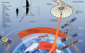
JOSAPHAT Tetuko Sri Sumantyo"s big dream began when he was only five years old. Josh, short for Josaphat, hoped someday to produce a radar satellite for Indonesia, a dream that went beyond the imagination of most children his age. He wanted to see Indonesia produce its own satellites instead of purchasing or renting from other countries.
It all began when his father, Michael Suman Juswaljati, an instructor at the Air Force Rapid Deployment Forcenow the Indonesian Military"s Air Force Special Commandotook little Josh to the Adi Soemarmo Air Base in Solo. There, he was blown away by the line of radar transmitters that kept rotating to show the presence of aircrafts in the sky over Solo and its surrounding area.
It was as if Josh was enjoying a new toy. He continued to observe the radar grids, but his amazement began to wane when he realized the sophisticated technology was not created by Indonesians. From then on, Josh was haunted by the idea to build a radar satellite. The opportunity to realize the big dream finally arrived in 2013.
As a remote sensing professor at Chiba University, Japan, Josh was allowed the opportunity to develop a radar satellite by himself. Under the Josaphat Microwave Remote Sensing Laboratory, Chiba University, Josh has been cooperating with the National Aeronautics and Space Institute (Lapan) in developing a micro satellite. Both institutions have agreed to build a micro satellite with a circularly polarized synthetic aperture radar (CP-SAR) sensor. The satellite has been named the LAPAN-Chibasat.
"It's really incredible that my childhood dream has come true," Josh told Tempo via email last Monday. As planned, the LAPAN-Chibasat will be launched in 2020 and will be navigated from Lapan's Satellite Main Control Station at Rancabungur, Bogor, West Java. The estimated cost of producing the micro satellite is US$6 million or around Rp79.8 billion, excluding intellectual property rights and personnel.
The adjective 'micro' was attached to the LAPAN-Chibasat because the satellite weighs only 150 kilogramsthe lightest satellite in the world capable of carrying a radar sensor. So far, satellites of the kind have weighed more than one ton and uses a linear polarized SAR. Josh has tinkered with the most current technologies for years to reduce the satellite's size and weight to one-tenth of the norm.
The LAPAN-Chibasat will work like a bat and shark in search for prey. Its antenna transmits microwaves in a circularly polarized model with a right-left rotation and again receives the waves to catch the image of the object it's facing. This method can reduce the device's vibration and its Faraday rotation effect more than the linear pattern. The Faraday rotation effect frequently occurs in the ionosphere, when light interacts with the magnetic field contained in the electrical insulator.
Like a bat, this radar satellite can also operate during nighttime. Unlike ordinary camera-image satellites, the LAPAN-Chibasat can gather information on the intensity, phase and patterns of an object. "This way, the image captured will be more accurate than that of a conventional radar sensor," said Josh. The CP-SAR technology and satellite dimension reduction are Josh's inventions and have been patented.
The CP-SAR radar sensor works at the frequency of 1,270 gigahertz (GHz), or the L band range. The wave length is 23 centimeters. This enables the LAPAN-Chibasat to penetrate clouds, fog, smoke, forests and to pass through the soil. Apart from the L band, the sensor can also capture the frequencies of the C band (5.3 GHz), X band (9.4 GHz) and Ku band (13.2 GHz), depending on the target observed. The higher the frequency, the greater the detail of the image gained.
"This will be the most sophisticated satellite owned by Indonesia," said Robertus Heru Triharjanto, a researcher from Lapan's Satellite Technology Center and a LAPAN-Chibasat team member. "The main mission of this satellite is earth observation."
Its application in Indonesia can cover many aspects such as sea traffic and border security, volcanic eruptions, forest fires, illegal fishing monitoring, infrastructure maintenance as well as shifts that can result in earthquakes and landslides.
Later, data collection and processing will be handled by Lapan and Chiba University. "But we haven't yet adopted a satellite image pricing policy because we're still waiting for the satellite to operate properly in orbit," he said. Robertus added that the satellite was not developed for business purposes due to the team's basic aim of technological command.
Laksana Tri Handoko, Indonesian Institute of Sciences' engineering science deputy, described the LAPAN-Chibasat as capable of taking the pictures of the Indonesian Archipelago's surface. "However, the images produced are similar to medical ultrasonography or USG images. So more profound analyses will be needed for the further use of the acquired data," said Laksana, who is not a team member. Nonetheless, in his view, the existence of the LAPAN-Chibasat is quite a breakthrough as Indonesia has thus far been left behind in satellite production.
Head of the Marine and Coastal Data Laboratory at the Ministry of Maritime Affairs and Fisheries, Widodo Setiyo Pranowo, referred to the LAPAN-Chibasat as a new weapon for marine research. "Especially if several satellites can operate. All parts of Indonesia's territorial waters can covered," he said.
According to Josh's calculations, it takes five satellites with a polar orbit, from the north pole to the south pole, to enable observing Indonesia's entire territory, or two satellites with an equatorial orbit. While in orbit, the LAPAN-Chibasat will be circling the earth at the height of around 570 kilometers. The micro satellite will go around the globe every two hours and will be above the Indonesian territory every four to six days.
Amri Mahbub