Setting Boundary Lines to Protect Lakes
Monday, December 2, 2024
The regulation on determining lake boundaries begins to be executed. It reduces repurposing and state losses resulting from the loss of lakes.
arsip tempo : 174557691720.

AT the age of 90, Tolib Sahari still remembers the history of Situ (lake) Gugur in what is now known as Pasir Putih village, Sawangan subdistrict, Depok City, West Java. The lake’s water was once clear, making it suitable for the surrounding residents to use for ablution. Its abundant water supply was utilized to power rubber mills owned by the Dutch colonial government.
Lake Gugur, covering 8 hectares, was also used by the Dutch to power a rice mill. The lake was dammed with soil, not rocks, and its channels were dredged three times a year. “The Dutch were organized, so the irrigation system was well-maintained,” said Tolib, now an elder in Pasir Putih.
Tolib recalls that the fate of Lake Gugur changed after the Dutch left. Maintenance of the water channels ceased, leading to the dam’s collapse in 1965. Tolib remembers that the event occurred just three weeks before the September 30 Movement tragedy. “When the dam broke, the water and fish spread all the way to Parung Bingung,” he recounted during a visit to his home on Friday, October 18, 2024.
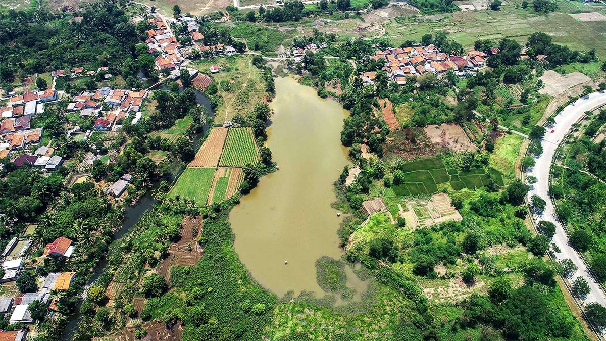
The lake area, later known as Lake Pasir Putih, has continued to shrink, and rainwater no longer fills it. Today, the lake’s face is a patchwork of fields, residential areas, and vacant land. If there are any remaining bodies of water, they are merely narrow water channels running through the area. Additionally, there are some several privately owned ponds or pools.
An even more tragic fate befell Lake Krukut, located not far from Pasir Putih. It was originally a small lake of about 1 hectare with clear water that could be consumed by locals. Now it measures just 3,000 square meters consisting of a man-made lake, surrounded by housing, factories, and toll roads.
Intended as a water catchment area, Lake Krukut is now facing ‘extinction’ due to a lack of maintenance, according to Husein Tohir, a local community leader. The lake has suffered sedimentation, and revitalization is urgently needed.
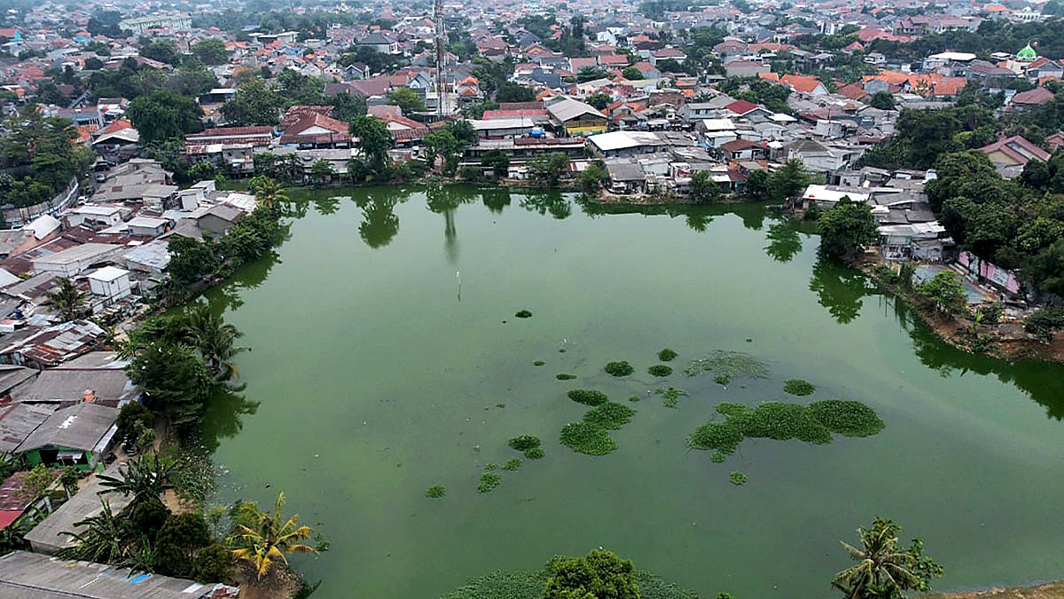
What is left of Lake Pasir Putih artificial lake in Depok, October 24, 2024. TEMPO/Ricky Juliansyah
According to Husein, Chair of the Krukut Village Empowerment Institution, the lack of budget for maintenance has led to the neglect of many lakes. He also pointed to the fate of the original Lake Krukut. “If the maintenance budget is provided, perhaps the community will take responsibility for maintaining the lake,” he said during a meeting on Monday, October 21.
In South Tangerang City, Banten, the situation has become even more complicated. Once pristine lakes have not only shrunk but also become disputed land sites. This is the case with Lake Rompong, located in Cempaka Putih village, Ciputat Timur subdistrict.
Chalimi, Head of the Community Unit (RT) 05 of Neighborhood Unit (RW) 05 in Cempaka Putih, reported that 23 of his residents were accused of trespassing on private land around the lake. They were reported to the South Tangerang District Attorney by unknown parties.
“Two months ago, we were called by the Banten Regional Police,” said Chalimi on Sunday, October 13. He added, “The targets were those who sold things out front. They were told to vacate.”
The residents chose to fight back using legal counsel, questioning the accusations of violations made in May 2023, as they had been living there for more than 25 years. “Where exactly is the land that’s being disputed?” asked Tobing, another local resident, on Sunday, November 3.
The area of Lake Rompong now covers only 1.7 hectares. According to Chalimi, Tobing, and other sources, the lake once spanned 10 hectares. A significant portion of that area is now residential housing, with the lake’s edge reduced to a narrow path between the water and the nearest buildings. Empty land around the lake has been designated for building rights, and ownership disputes extend to parts of the lake’s water body.
Lake Rompong artificial lake in Ciputat, South Tangerang. TEMPO/Muhammad Iqbal
Muhammad Adek Rizaldi, Director of Operations and Maintenance at the Ministry of Public Works and People’s Housing (PUPR), acknowledged that there have been no regulations in place to govern state-owned assets such as lakes and reservoirs. “These bodies of water exist naturally without proof of ownership,” he said when Tempo met him at his office on Monday, September 23.
He provided an illustration of the difference between state assets like dams, which are created after the land is first acquired by the government, explaining that occupation of lakes is often unavoidable and sometimes results in lakes being displaced. Adek revealed that the Finance Ministry is currently drafting the State Asset Management Bill.
According to Adek, without regulation, education, and public understanding about the importance of conservation, it has proven insufficient to protect the sustainability of lakes from the pressures of population growth. Lakes, which are intended as water catchment areas, are often exploited for housing, production areas, and farming.
“Once exploitation begins, sedimentation follows. Sediment enters the lake, causing it to shallow, and at that point, people start to think, ‘Hey, this is empty land. It can be used,’” Adek explained.
Adek acknowledged that the Public Works Ministry is not turning a blind eye to this issue. That is why the Ministry is running a pilot project to establish boundaries for 30 lakes while waiting for the passage of the State Asset Management Bill. These lakes were selected from 117 lakes in four areas under the jurisdiction of the West Java and Banten river basin offices.
The project, in collaboration with the Deputy for Prevention of the Corruption Eradication Commission (KPK), is implementing the Public Works and People’s Housing Minister Regulation No. 28/2015 on the Determination of River and Lake Boundaries. The goal is to issue boundary lines for each lake by the end of December.
“Once the boundaries are set, we will begin to mark the areas to prevent the construction of buildings that do not comply with their intended use,” Adek said.
Based on a program already implemented on eight major priority lakes, the establishment of boundaries is expected to preserve the water-holding capacity of each lake. “The point is that we aim to restore the lakes to their original condition,” Adek concluded.
Regulation No. 28/2015 defines a lake boundary as the area of land surrounding the lake, extending 50 meters from the highest water level ever recorded. This area is designated as a protective zone or water catchment area for the lake.
The boundary decree does not regulate land acquisition, but it governs land use within the boundary area. It establishes the status quo for buildings already existing within the boundary. These buildings cannot be renovated or expanded until they are no longer usable, after which they must be removed from the boundary area. “Gradually, these will be regulated,” said Adek.
The boundary decree project begins with the formation of a team that reviews data and determines the field boundaries for each selected lake. The findings are then reported to the local community before being submitted to the minister, governor, or regent/mayor. During the reporting phase, Adek said that some processes had to be repeated due to data discrepancies or incomplete information.
He mentioned a lake in Garut, West Java, where verification had to be repeated due to newly discovered land ownership by the village head. Even though there are fewer buildings around the lake, the certification of land ownership around the lake remains problematic, just like with lakes in densely populated areas.
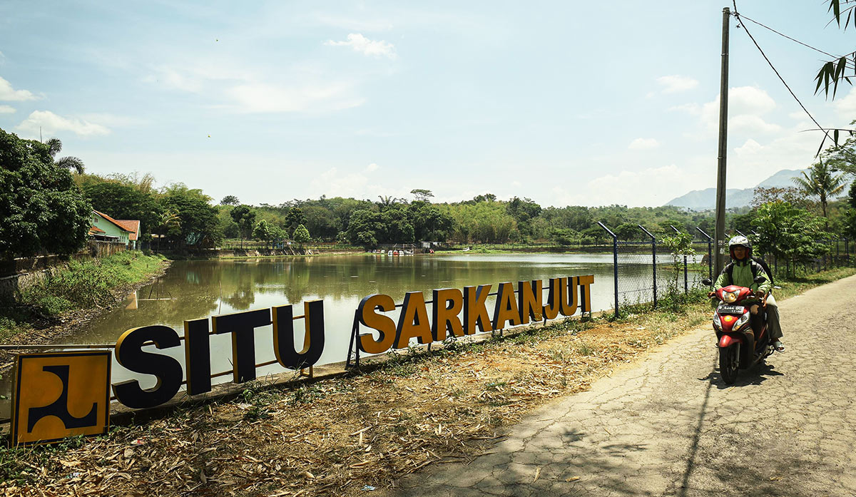
Lake (Situ) Sarkanjut in Garut, West Java, October 24, 2024. TEMPO/M Taufan Rengganis
In addition to numerous land ownership certificates, Lake Sarkanjut in Dungusiku village, for example, has several public buildings within the boundary area. The Village Secretary, Enisa Suherman, shared the outcome of a discussion with the Cimanuk-Cisanggarung River Basin Office team on September 11. It was revealed that the lake boundary line cut across a hectare of land owned by residents, totaling 1 hectare. The total area of land owned by the village, including a cemetery, health post, village-owned business, and school, is 2.5 hectares.
Enisa noted that local residents expect clarity regarding the status and use of the land following the boundary determination. They would strongly oppose any ambiguity. Meanwhile, for the village government, Enisa said, “The boundary decree policy has become an obstacle for planning tourism in Dungusiku village.”
A similar atmosphere emerged in the discussions about setting boundaries for four selected lakes in Lebak Regency, Banten, on Thursday, October 17. Many meeting participants hesitated to sign the discussion minutes. “Does signing this mean agreeing with the study?” they asked.
I Ketut Jayada, Head of the Cidanau-Ciujung-Cidurian River Basin Office, which oversees the four lakes, explained that two of the lakes, Cicinta and Cikuda, had shrunk due to the construction of housing complexes. In Lake Cikuda, the boundary determination would reduce the total lake area in Rangkasbitung Timur village from an existing water body of 7,200 square meters to 5.44 hectares.
Lake Cicinta in Maja, Lebak, Banten, Friday, October 25, 2024. TEMPO/M Taufan Rengganis
The size of Lake Cicinta, located in Maja subdistrict, will increase from 12.87 hectares to 21.07 hectares. “We hope that with the establishment of the boundary decree, the size of lakes in Lebak will no longer decrease,” said Ketut in his office in Serang City on Thursday, October 17.
Lake Rompong in Cempaka Putih village, Ciputat Timur subdistrict, South Tangerang City, is also part of the 30 pilot projects for the boundary decree. The local residents have reported that there has already been a dissemination effort for the installation of boundary markers by the Ciliwung Cisadane River Basin Office team in the area. The residents expressed their agreement with the status quo provision and ultimately agreed to comply with the regulations.
However, they have set conditions. “We are willing to leave the land as long as it applies equally to both developers and residential communities,” said Tobing.
Sudrajat Mingan, a member of the National Strategy Team for Corruption Prevention at KPK’s Deputy for Prevention, expressed his support for assisting the Public Works Ministry in curbing the loss rate of lakes. He explained that lakes function as water catchment areas that can prevent floods and have economic value through their utilization.
Therefore, when these lakes disappear, he added, there is a potential state loss. “The potential for land-use conversion is significant because, based on our study of just 30 lakes, many bodies of water have already been granted ownership rights,” Sudrajat said.